|
|
|||||||||||||||||
| Point ID: 791 | Downloads | Plots | Site Data | Code: 07JC001 |
|
|
|||||||||||||||||
| Download | |
|---|---|
| Site Descriptor Information | Site Time Series Data |
| Link to all available data | |
| View: | Time Series | All |
| Units: | mm |
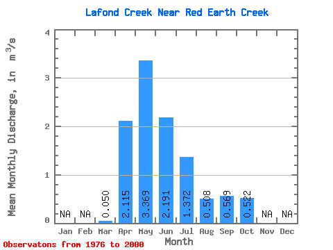
| Statistic | Jan | Feb | Mar | Apr | May | Jun | Jul | Aug | Sep | Oct | Nov | Dec | Annual |
|---|---|---|---|---|---|---|---|---|---|---|---|---|---|
| Mean | 0.05 | 2.12 | 3.37 | 2.19 | 1.37 | 0.51 | 0.57 | 0.52 | |||||
| Standard Deviation | 0.15 | 1.40 | 2.65 | 2.22 | 1.85 | 0.74 | 1.18 | 0.72 | |||||
| Min | 0.00 | 0.05 | 0.06 | 0.02 | 0.01 | 0.00 | 0.00 | 0.00 | |||||
| Max | 0.77 | 5.15 | 9.53 | 8.33 | 7.81 | 3.29 | 5.33 | 3.13 | |||||
| Coefficient of Variation | 3.02 | 0.66 | 0.79 | 1.01 | 1.35 | 1.46 | 2.08 | 1.37 |
 Return to R-Arctic Net Home Page