|
|
|||||||||||||||||
| Point ID: 790 | Downloads | Plots | Site Data | Code: 07JB002 |
|
|
|||||||||||||||||
| Download | |
|---|---|
| Site Descriptor Information | Site Time Series Data |
| Link to all available data | |
| View: | Time Series | All |
| Units: | mm |
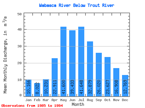
| Statistic | Jan | Feb | Mar | Apr | May | Jun | Jul | Aug | Sep | Oct | Nov | Dec | Annual |
|---|---|---|---|---|---|---|---|---|---|---|---|---|---|
| Mean | 10.17 | 8.02 | 10.23 | 22.91 | 41.60 | 39.43 | 41.65 | 32.88 | 26.02 | 23.63 | 16.91 | 12.77 | 23.78 |
| Standard Deviation | 5.45 | 3.54 | 5.14 | 11.24 | 26.77 | 16.31 | 35.78 | 24.95 | 15.27 | 11.20 | 8.01 | 6.73 | 5.94 |
| Min | 2.86 | 2.90 | 3.80 | 10.80 | 14.30 | 16.00 | 6.23 | 8.21 | 8.70 | 9.34 | 5.74 | 3.83 | 11.50 |
| Max | 18.40 | 13.30 | 19.60 | 39.90 | 94.30 | 62.60 | 127.00 | 81.10 | 48.10 | 43.40 | 33.10 | 23.70 | 33.74 |
| Coefficient of Variation | 0.54 | 0.44 | 0.50 | 0.49 | 0.64 | 0.41 | 0.86 | 0.76 | 0.59 | 0.47 | 0.47 | 0.53 | 0.25 |
 Return to R-Arctic Net Home Page