|
|
|||||||||||||||||
| Point ID: 788 | Downloads | Plots | Site Data | Code: 07HF002 |
|
|
|||||||||||||||||
| Download | |
|---|---|
| Site Descriptor Information | Site Time Series Data |
| Link to all available data | |
| View: | Time Series | All |
| Units: | mm |
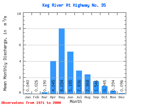
| Statistic | Jan | Feb | Mar | Apr | May | Jun | Jul | Aug | Sep | Oct | Nov | Dec | Annual |
|---|---|---|---|---|---|---|---|---|---|---|---|---|---|
| Mean | 0.04 | 0.03 | 0.19 | 4.04 | 8.03 | 5.18 | 2.84 | 2.37 | 1.55 | 0.94 | 0.39 | 0.10 | 2.58 |
| Standard Deviation | 0.03 | 0.04 | 0.48 | 2.88 | 5.49 | 4.59 | 2.36 | 3.56 | 2.65 | 1.36 | 0.29 | 0.04 | 0.47 |
| Min | 0.00 | 0.00 | 0.00 | 0.78 | 1.29 | 0.41 | 0.05 | 0.12 | 0.01 | 0.07 | 0.15 | 0.04 | 1.55 |
| Max | 0.09 | 0.13 | 2.25 | 12.40 | 20.50 | 17.70 | 9.57 | 15.00 | 11.90 | 6.36 | 0.85 | 0.18 | 2.94 |
| Coefficient of Variation | 0.73 | 1.69 | 2.51 | 0.71 | 0.68 | 0.88 | 0.83 | 1.50 | 1.71 | 1.44 | 0.74 | 0.47 | 0.18 |
 Return to R-Arctic Net Home Page