|
|
|||||||||||||||||
| Point ID: 7869 | Downloads | Plots | Site Data | Code: 3338 |
|
|
|||||||||||||||||
| Download | |
|---|---|
| Site Descriptor Information | Site Time Series Data |
| Link to all available data | |
| View: | Time Series | All |
| Units: | mm |
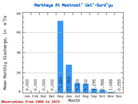
| Statistic | Jan | Feb | Mar | Apr | May | Jun | Jul | Aug | Sep | Oct | Nov | Dec | Annual |
|---|---|---|---|---|---|---|---|---|---|---|---|---|---|
| Mean | 0.00 | 0.00 | 0.00 | 0.00 | 71.66 | 27.97 | 9.62 | 9.00 | 4.29 | 2.99 | 1.09 | 0.26 | 10.94 |
| Standard Deviation | 0.00 | 0.00 | 0.00 | 0.00 | 33.91 | 17.07 | 9.51 | 16.26 | 3.88 | 2.56 | 1.49 | 0.31 | 6.50 |
| Min | 0.00 | 0.00 | 0.00 | 0.00 | 37.80 | 6.31 | 1.17 | 0.88 | 0.86 | 0.56 | 0.10 | 0.00 | 4.72 |
| Max | 0.00 | 0.00 | 0.00 | 0.01 | 126.00 | 57.80 | 21.20 | 38.00 | 9.37 | 6.11 | 3.28 | 0.62 | 19.27 |
| Coefficient of Variation | 2.24 | 0.47 | 0.61 | 0.99 | 1.81 | 0.90 | 0.86 | 1.37 | 1.21 | 0.59 |
 Return to R-Arctic Net Home Page