|
|
|||||||||||||||||
| Point ID: 7852 | Downloads | Plots | Site Data | Code: 3263 |
|
|
|||||||||||||||||
| Download | |
|---|---|
| Site Descriptor Information | Site Time Series Data |
| Link to all available data | |
| View: | Time Series | All |
| Units: | mm |
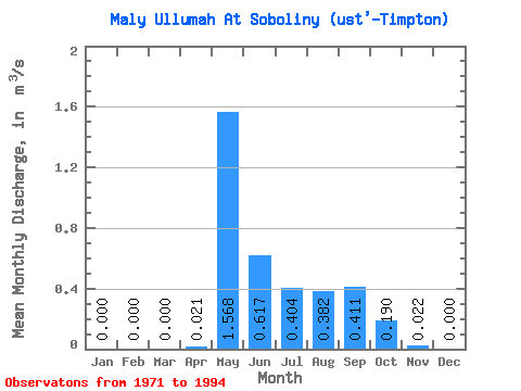
| Statistic | Jan | Feb | Mar | Apr | May | Jun | Jul | Aug | Sep | Oct | Nov | Dec | Annual |
|---|---|---|---|---|---|---|---|---|---|---|---|---|---|
| Mean | 0.00 | 0.00 | 0.00 | 0.02 | 1.57 | 0.62 | 0.40 | 0.38 | 0.41 | 0.19 | 0.02 | 0.00 | 0.32 |
| Standard Deviation | 0.00 | 0.00 | 0.00 | 0.04 | 0.49 | 0.33 | 0.34 | 0.34 | 0.26 | 0.13 | 0.03 | 0.00 | 0.08 |
| Min | 0.00 | 0.00 | 0.00 | 0.00 | 0.86 | 0.17 | 0.08 | 0.02 | 0.06 | 0.00 | 0.00 | 0.00 | 0.16 |
| Max | 0.00 | 0.00 | 0.00 | 0.17 | 2.34 | 1.37 | 1.67 | 1.42 | 0.87 | 0.49 | 0.09 | 0.00 | 0.44 |
| Coefficient of Variation | 2.13 | 0.31 | 0.53 | 0.83 | 0.90 | 0.63 | 0.70 | 1.14 | 0.25 |
 Return to R-Arctic Net Home Page