|
|
|||||||||||||||||
| Point ID: 7841 | Downloads | Plots | Site Data | Code: 3244 |
|
|
|||||||||||||||||
| Download | |
|---|---|
| Site Descriptor Information | Site Time Series Data |
| Link to all available data | |
| View: | Time Series | All |
| Units: | mm |
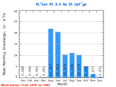
| Statistic | Jan | Feb | Mar | Apr | May | Jun | Jul | Aug | Sep | Oct | Nov | Dec | Annual |
|---|---|---|---|---|---|---|---|---|---|---|---|---|---|
| Mean | 0.09 | 0.01 | 0.00 | 0.25 | 21.77 | 20.35 | 10.32 | 11.01 | 10.12 | 5.13 | 1.58 | 0.37 | 6.77 |
| Standard Deviation | 0.20 | 0.02 | 0.01 | 0.31 | 7.20 | 7.61 | 3.40 | 6.29 | 4.64 | 2.28 | 0.75 | 0.45 | 1.26 |
| Min | 0.00 | 0.00 | 0.00 | 0.00 | 7.34 | 11.40 | 6.48 | 3.41 | 3.37 | 1.85 | 0.29 | 0.00 | 5.20 |
| Max | 0.78 | 0.06 | 0.02 | 0.99 | 33.00 | 35.60 | 17.50 | 23.10 | 21.40 | 11.40 | 2.99 | 1.43 | 9.01 |
| Coefficient of Variation | 2.30 | 2.86 | 4.00 | 1.23 | 0.33 | 0.37 | 0.33 | 0.57 | 0.46 | 0.44 | 0.47 | 1.20 | 0.19 |
 Return to R-Arctic Net Home Page