|
|
|||||||||||||||||
| Point ID: 7838 | Downloads | Plots | Site Data | Code: 3233 |
|
|
|||||||||||||||||
| Download | |
|---|---|
| Site Descriptor Information | Site Time Series Data |
| Link to all available data | |
| View: | Time Series | All |
| Units: | mm |
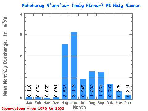
| Statistic | Jan | Feb | Mar | Apr | May | Jun | Jul | Aug | Sep | Oct | Nov | Dec | Annual |
|---|---|---|---|---|---|---|---|---|---|---|---|---|---|
| Mean | 0.12 | 0.07 | 0.06 | 0.09 | 2.54 | 3.12 | 0.94 | 1.29 | 1.25 | 0.71 | 0.38 | 0.21 | 0.90 |
| Standard Deviation | 0.09 | 0.08 | 0.07 | 0.09 | 1.13 | 2.40 | 0.32 | 0.85 | 0.49 | 0.34 | 0.15 | 0.08 | 0.21 |
| Min | 0.00 | 0.00 | 0.00 | 0.00 | 0.44 | 0.52 | 0.47 | 0.51 | 0.38 | 0.26 | 0.12 | 0.04 | 0.51 |
| Max | 0.38 | 0.24 | 0.22 | 0.28 | 4.51 | 9.50 | 1.52 | 4.64 | 2.86 | 1.43 | 0.74 | 0.38 | 1.34 |
| Coefficient of Variation | 0.76 | 1.05 | 1.26 | 1.00 | 0.45 | 0.77 | 0.34 | 0.66 | 0.39 | 0.47 | 0.39 | 0.39 | 0.23 |
 Return to R-Arctic Net Home Page