|
|
|||||||||||||||||
| Point ID: 7837 | Downloads | Plots | Site Data | Code: 3232 |
|
|
|||||||||||||||||
| Download | |
|---|---|
| Site Descriptor Information | Site Time Series Data |
| Link to all available data | |
| View: | Time Series | All |
| Units: | mm |
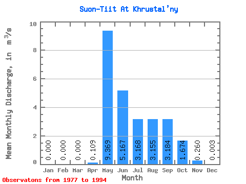
| Statistic | Jan | Feb | Mar | Apr | May | Jun | Jul | Aug | Sep | Oct | Nov | Dec | Annual |
|---|---|---|---|---|---|---|---|---|---|---|---|---|---|
| Mean | 0.00 | 0.00 | 0.00 | 0.11 | 9.37 | 5.17 | 3.17 | 3.15 | 3.18 | 1.67 | 0.26 | 0.00 | 2.52 |
| Standard Deviation | 0.00 | 0.00 | 0.00 | 0.14 | 3.99 | 2.53 | 1.89 | 2.27 | 2.14 | 0.95 | 0.31 | 0.01 | 0.85 |
| Min | 0.00 | 0.00 | 0.00 | 0.00 | 3.15 | 1.40 | 0.51 | 0.32 | 0.54 | 0.27 | 0.00 | 0.00 | 0.86 |
| Max | 0.00 | 0.00 | 0.00 | 0.53 | 15.90 | 8.94 | 6.82 | 8.02 | 7.60 | 3.55 | 0.90 | 0.03 | 3.90 |
| Coefficient of Variation | 1.28 | 0.43 | 0.49 | 0.60 | 0.72 | 0.67 | 0.57 | 1.19 | 3.16 | 0.34 |
 Return to R-Arctic Net Home Page