|
|
|||||||||||||||||
| Point ID: 7823 | Downloads | Plots | Site Data | Code: 3184 |
|
|
|||||||||||||||||
| Download | |
|---|---|
| Site Descriptor Information | Site Time Series Data |
| Link to all available data | |
| View: | Time Series | All |
| Units: | mm |
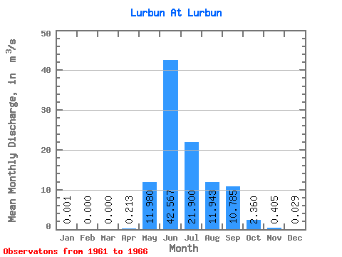
| Statistic | Jan | Feb | Mar | Apr | May | Jun | Jul | Aug | Sep | Oct | Nov | Dec | Annual |
|---|---|---|---|---|---|---|---|---|---|---|---|---|---|
| Mean | 0.00 | 0.00 | 0.00 | 0.21 | 11.98 | 42.57 | 21.90 | 11.94 | 10.79 | 2.36 | 0.41 | 0.03 | 8.52 |
| Standard Deviation | 0.00 | 0.00 | 0.00 | 0.11 | 5.53 | 9.62 | 7.59 | 7.59 | 4.06 | 0.63 | 0.30 | 0.06 | 1.03 |
| Min | 0.00 | 0.00 | 0.00 | 0.00 | 7.44 | 26.80 | 11.30 | 3.83 | 7.72 | 1.66 | 0.12 | 0.00 | 7.79 |
| Max | 0.00 | 0.00 | 0.00 | 0.30 | 22.10 | 53.50 | 32.20 | 24.40 | 18.70 | 3.26 | 0.78 | 0.15 | 10.51 |
| Coefficient of Variation | 2.45 | 0.53 | 0.46 | 0.23 | 0.35 | 0.64 | 0.38 | 0.27 | 0.73 | 2.06 | 0.12 |
 Return to R-Arctic Net Home Page