|
|
|||||||||||||||||
| Point ID: 782 | Downloads | Plots | Site Data | Code: 07HB002 |
|
|
|||||||||||||||||
| Download | |
|---|---|
| Site Descriptor Information | Site Time Series Data |
| Link to all available data | |
| View: | Time Series | All |
| Units: | mm |
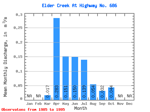
| Statistic | Jan | Feb | Mar | Apr | May | Jun | Jul | Aug | Sep | Oct | Nov | Dec | Annual |
|---|---|---|---|---|---|---|---|---|---|---|---|---|---|
| Mean | 0.02 | 0.28 | 0.15 | 0.15 | 0.14 | 0.05 | 0.03 | 0.04 | |||||
| Standard Deviation | 0.03 | 0.25 | 0.14 | 0.18 | 0.22 | 0.13 | 0.09 | 0.09 | |||||
| Min | 0.00 | 0.02 | 0.00 | 0.00 | 0.00 | 0.00 | 0.00 | 0.00 | |||||
| Max | 0.11 | 0.70 | 0.42 | 0.53 | 0.70 | 0.45 | 0.31 | 0.32 | |||||
| Coefficient of Variation | 1.88 | 0.90 | 0.90 | 1.18 | 1.56 | 2.47 | 2.87 | 2.15 |
 Return to R-Arctic Net Home Page