|
|
|||||||||||||||||
| Point ID: 7815 | Downloads | Plots | Site Data | Code: 3143 |
|
|
|||||||||||||||||
| Download | |
|---|---|
| Site Descriptor Information | Site Time Series Data |
| Link to all available data | |
| View: | Time Series | All |
| Units: | mm |
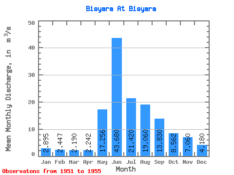
| Statistic | Jan | Feb | Mar | Apr | May | Jun | Jul | Aug | Sep | Oct | Nov | Dec | Annual |
|---|---|---|---|---|---|---|---|---|---|---|---|---|---|
| Mean | 2.90 | 2.45 | 2.19 | 2.24 | 17.26 | 43.68 | 21.42 | 19.06 | 13.83 | 8.56 | 7.06 | 4.18 | 11.68 |
| Standard Deviation | 0.32 | 0.39 | 0.39 | 0.41 | 8.31 | 12.60 | 4.69 | 10.65 | 3.76 | 3.29 | 2.88 | 1.29 | 2.39 |
| Min | 2.42 | 1.89 | 1.67 | 1.65 | 6.48 | 29.30 | 16.10 | 10.80 | 8.15 | 4.31 | 3.70 | 2.48 | 8.28 |
| Max | 3.08 | 2.79 | 2.61 | 2.58 | 24.00 | 63.30 | 28.10 | 37.40 | 17.40 | 12.60 | 9.92 | 5.48 | 13.68 |
| Coefficient of Variation | 0.11 | 0.16 | 0.18 | 0.18 | 0.48 | 0.29 | 0.22 | 0.56 | 0.27 | 0.38 | 0.41 | 0.31 | 0.20 |
 Return to R-Arctic Net Home Page