|
|
|||||||||||||||||
| Point ID: 7813 | Downloads | Plots | Site Data | Code: 3141 |
|
|
|||||||||||||||||
| Download | |
|---|---|
| Site Descriptor Information | Site Time Series Data |
| Link to all available data | |
| View: | Time Series | All |
| Units: | mm |
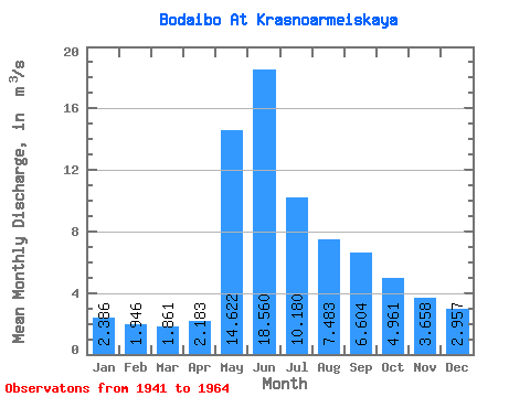
| Statistic | Jan | Feb | Mar | Apr | May | Jun | Jul | Aug | Sep | Oct | Nov | Dec | Annual |
|---|---|---|---|---|---|---|---|---|---|---|---|---|---|
| Mean | 2.39 | 1.95 | 1.86 | 2.18 | 14.62 | 18.56 | 10.18 | 7.48 | 6.60 | 4.96 | 3.66 | 2.96 | 6.46 |
| Standard Deviation | 0.44 | 0.41 | 0.30 | 0.70 | 3.61 | 7.65 | 3.14 | 2.04 | 1.76 | 1.23 | 0.82 | 0.65 | 1.00 |
| Min | 1.61 | 1.11 | 1.15 | 1.60 | 8.17 | 6.55 | 4.50 | 4.25 | 4.33 | 2.96 | 2.42 | 2.12 | 4.33 |
| Max | 3.41 | 2.62 | 2.35 | 5.02 | 22.40 | 33.70 | 16.30 | 12.80 | 10.30 | 7.06 | 5.02 | 4.21 | 8.22 |
| Coefficient of Variation | 0.18 | 0.21 | 0.16 | 0.32 | 0.25 | 0.41 | 0.31 | 0.27 | 0.27 | 0.25 | 0.23 | 0.22 | 0.15 |
 Return to R-Arctic Net Home Page