|
|
|||||||||||||||||
| Point ID: 7809 | Downloads | Plots | Site Data | Code: 3125 |
|
|
|||||||||||||||||
| Download | |
|---|---|
| Site Descriptor Information | Site Time Series Data |
| Link to all available data | |
| View: | Time Series | All |
| Units: | mm |
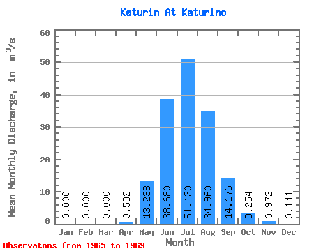
| Statistic | Jan | Feb | Mar | Apr | May | Jun | Jul | Aug | Sep | Oct | Nov | Dec | Annual |
|---|---|---|---|---|---|---|---|---|---|---|---|---|---|
| Mean | 0.00 | 0.00 | 0.00 | 0.58 | 13.24 | 38.68 | 51.12 | 34.96 | 14.18 | 3.25 | 0.97 | 0.14 | 13.09 |
| Standard Deviation | 0.00 | 0.00 | 0.00 | 1.28 | 9.83 | 22.45 | 17.16 | 14.12 | 6.47 | 1.36 | 0.55 | 0.19 | 1.91 |
| Min | 0.00 | 0.00 | 0.00 | 0.00 | 0.64 | 14.70 | 28.80 | 22.30 | 7.51 | 2.12 | 0.49 | 0.03 | 9.68 |
| Max | 0.00 | 0.00 | 0.00 | 2.87 | 27.70 | 70.50 | 74.90 | 55.00 | 24.20 | 5.43 | 1.91 | 0.48 | 14.18 |
| Coefficient of Variation | 2.20 | 0.74 | 0.58 | 0.34 | 0.40 | 0.46 | 0.42 | 0.56 | 1.38 | 0.15 |
 Return to R-Arctic Net Home Page