|
|
|||||||||||||||||
| Point ID: 7792 | Downloads | Plots | Site Data | Code: 3066 |
|
|
|||||||||||||||||
| Download | |
|---|---|
| Site Descriptor Information | Site Time Series Data |
| Link to all available data | |
| View: | Time Series | All |
| Units: | mm |
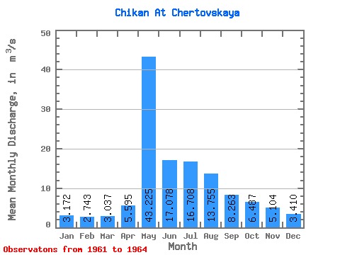
| Statistic | Jan | Feb | Mar | Apr | May | Jun | Jul | Aug | Sep | Oct | Nov | Dec | Annual |
|---|---|---|---|---|---|---|---|---|---|---|---|---|---|
| Mean | 3.17 | 2.74 | 3.04 | 5.59 | 43.23 | 17.08 | 16.71 | 13.76 | 8.26 | 6.49 | 5.10 | 3.41 | 10.73 |
| Standard Deviation | 1.07 | 1.32 | 1.44 | 4.21 | 18.19 | 7.95 | 11.58 | 7.70 | 2.23 | 1.82 | 1.93 | 1.25 | 3.34 |
| Min | 2.03 | 1.24 | 1.06 | 1.74 | 23.60 | 7.81 | 6.32 | 7.00 | 5.88 | 4.42 | 2.92 | 2.27 | 6.93 |
| Max | 4.27 | 4.38 | 4.31 | 11.60 | 67.40 | 24.70 | 31.10 | 21.20 | 10.30 | 7.85 | 6.57 | 4.75 | 13.19 |
| Coefficient of Variation | 0.34 | 0.48 | 0.47 | 0.75 | 0.42 | 0.47 | 0.69 | 0.56 | 0.27 | 0.28 | 0.38 | 0.37 | 0.31 |
 Return to R-Arctic Net Home Page