|
|
|||||||||||||||||
| Point ID: 7780 | Downloads | Plots | Site Data | Code: 10UJ001 |
|
|
|||||||||||||||||
| Download | |
|---|---|
| Site Descriptor Information | Site Time Series Data |
| Link to all available data | |
| View: | Time Series | All |
| Units: | mm |
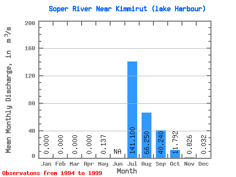
| Statistic | Jan | Feb | Mar | Apr | May | Jun | Jul | Aug | Sep | Oct | Nov | Dec | Annual |
|---|---|---|---|---|---|---|---|---|---|---|---|---|---|
| Mean | 0.00 | 0.00 | 0.00 | 0.00 | 0.14 | 141.10 | 66.25 | 40.24 | 11.79 | 0.83 | 0.03 | ||
| Standard Deviation | 0.00 | 0.00 | 0.00 | 0.00 | 125.72 | 18.32 | 3.67 | 3.50 | 1.15 | 0.06 | |||
| Min | 0.00 | 0.00 | 0.00 | 0.00 | 0.14 | 52.20 | 37.10 | 35.30 | 8.97 | 0.03 | 0.00 | ||
| Max | 0.00 | 0.00 | 0.00 | 0.00 | 0.14 | 230.00 | 88.30 | 43.90 | 16.90 | 2.14 | 0.10 | ||
| Coefficient of Variation | 0.89 | 0.28 | 0.09 | 0.30 | 1.39 | 1.73 |
 Return to R-Arctic Net Home Page