|
|
|||||||||||||||||
| Point ID: 778 | Downloads | Plots | Site Data | Code: 07HA003 |
|
|
|||||||||||||||||
| Download | |
|---|---|
| Site Descriptor Information | Site Time Series Data |
| Link to all available data | |
| View: | Time Series | All |
| Units: | mm |
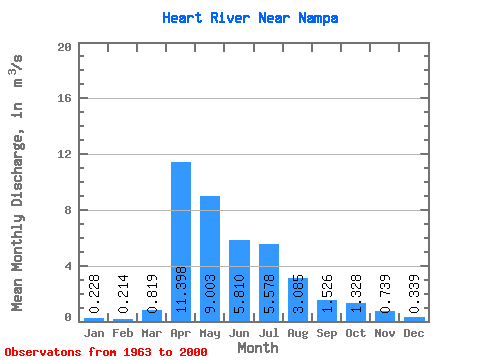
| Statistic | Jan | Feb | Mar | Apr | May | Jun | Jul | Aug | Sep | Oct | Nov | Dec | Annual |
|---|---|---|---|---|---|---|---|---|---|---|---|---|---|
| Mean | 0.23 | 0.21 | 0.82 | 11.40 | 9.00 | 5.81 | 5.58 | 3.08 | 1.53 | 1.33 | 0.74 | 0.34 | 3.18 |
| Standard Deviation | 0.10 | 0.10 | 1.79 | 12.56 | 9.69 | 7.33 | 7.71 | 8.01 | 2.56 | 1.54 | 0.62 | 0.19 | 2.63 |
| Min | 0.05 | 0.05 | 0.07 | 0.23 | 0.13 | 0.05 | 0.00 | 0.01 | 0.00 | 0.01 | 0.04 | 0.06 | 0.17 |
| Max | 0.40 | 0.57 | 10.30 | 45.40 | 34.30 | 26.80 | 28.00 | 46.80 | 10.10 | 5.75 | 2.44 | 0.86 | 11.38 |
| Coefficient of Variation | 0.43 | 0.47 | 2.19 | 1.10 | 1.08 | 1.26 | 1.38 | 2.60 | 1.68 | 1.16 | 0.83 | 0.55 | 0.83 |
 Return to R-Arctic Net Home Page