|
|
|||||||||||||||||
| Point ID: 7757 | Downloads | Plots | Site Data | Code: 05NB040 |
|
|
|||||||||||||||||
| Download | |
|---|---|
| Site Descriptor Information | Site Time Series Data |
| Link to all available data | |
| View: | Time Series | All |
| Units: | mm |
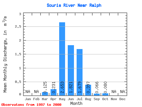
| Statistic | Jan | Feb | Mar | Apr | May | Jun | Jul | Aug | Sep | Oct | Nov | Dec | Annual |
|---|---|---|---|---|---|---|---|---|---|---|---|---|---|
| Mean | 0.12 | 0.23 | 2.65 | 1.82 | 1.68 | 0.40 | 0.07 | 0.08 | |||||
| Standard Deviation | 0.17 | 0.03 | 4.47 | 2.88 | 1.38 | 0.41 | 0.07 | 0.05 | |||||
| Min | 0.00 | 0.21 | 0.03 | 0.03 | 0.12 | 0.00 | 0.01 | 0.02 | |||||
| Max | 0.25 | 0.25 | 7.81 | 5.14 | 2.74 | 0.83 | 0.14 | 0.13 | |||||
| Coefficient of Variation | 1.38 | 0.14 | 1.68 | 1.58 | 0.82 | 1.04 | 1.01 | 0.63 |
 Return to R-Arctic Net Home Page