|
|
|||||||||||||||||
| Point ID: 775 | Downloads | Plots | Site Data | Code: 07GJ005 |
|
|
|||||||||||||||||
| Download | |
|---|---|
| Site Descriptor Information | Site Time Series Data |
| Link to all available data | |
| View: | Time Series | All |
| Units: | mm |
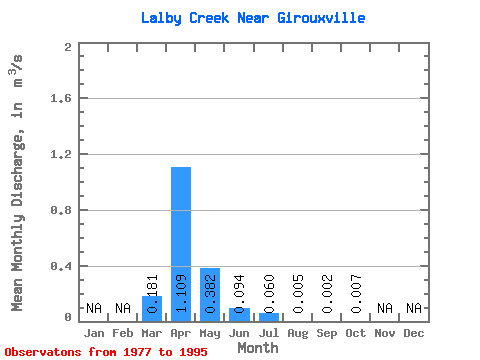
| Statistic | Jan | Feb | Mar | Apr | May | Jun | Jul | Aug | Sep | Oct | Nov | Dec | Annual |
|---|---|---|---|---|---|---|---|---|---|---|---|---|---|
| Mean | 0.18 | 1.11 | 0.38 | 0.09 | 0.06 | 0.01 | 0.00 | 0.01 | |||||
| Standard Deviation | 0.65 | 1.31 | 1.12 | 0.17 | 0.11 | 0.01 | 0.01 | 0.02 | |||||
| Min | 0.00 | 0.02 | 0.00 | 0.00 | 0.00 | 0.00 | 0.00 | 0.00 | |||||
| Max | 2.78 | 3.79 | 4.81 | 0.59 | 0.36 | 0.03 | 0.02 | 0.07 | |||||
| Coefficient of Variation | 3.59 | 1.18 | 2.92 | 1.76 | 1.79 | 1.36 | 2.89 | 2.69 |
 Return to R-Arctic Net Home Page