|
|
|||||||||||||||||
| Point ID: 7724 | Downloads | Plots | Site Data | Code: NO001 |
|
|
|||||||||||||||||
| Download | |
|---|---|
| Site Descriptor Information | Site Time Series Data |
| Link to all available data | |
| View: | Time Series | All |
| Units: | mm |
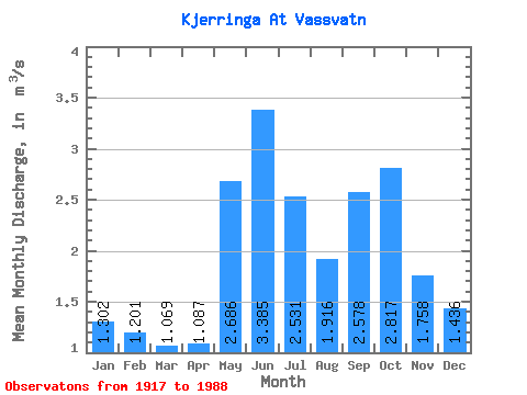
| Statistic | Jan | Feb | Mar | Apr | May | Jun | Jul | Aug | Sep | Oct | Nov | Dec | Annual |
|---|---|---|---|---|---|---|---|---|---|---|---|---|---|
| Mean | 1.30 | 1.20 | 1.07 | 1.09 | 2.69 | 3.38 | 2.53 | 1.92 | 2.58 | 2.82 | 1.76 | 1.44 | 1.98 |
| Standard Deviation | 1.21 | 1.27 | 0.93 | 0.64 | 1.02 | 1.05 | 1.21 | 1.24 | 1.14 | 1.39 | 1.01 | 0.97 | 0.39 |
| Min | 0.22 | 0.21 | 0.07 | 0.28 | 1.05 | 1.57 | 0.61 | 0.27 | 0.64 | 0.51 | 0.24 | 0.26 | 1.26 |
| Max | 6.88 | 7.71 | 5.20 | 3.00 | 5.49 | 6.76 | 7.17 | 6.99 | 5.55 | 6.29 | 4.71 | 4.09 | 2.98 |
| Coefficient of Variation | 0.93 | 1.05 | 0.87 | 0.59 | 0.38 | 0.31 | 0.48 | 0.65 | 0.44 | 0.49 | 0.57 | 0.68 | 0.20 |
 Return to R-Arctic Net Home Page