|
|
|||||||||||||||||
| Point ID: 7722 | Downloads | Plots | Site Data | Code: II006 |
|
|
|||||||||||||||||
| Download | |
|---|---|
| Site Descriptor Information | Site Time Series Data |
| Link to all available data | |
| View: | Time Series | All |
| Units: | mm |
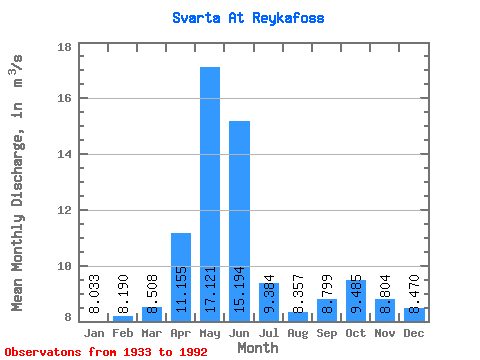
| Statistic | Jan | Feb | Mar | Apr | May | Jun | Jul | Aug | Sep | Oct | Nov | Dec | Annual |
|---|---|---|---|---|---|---|---|---|---|---|---|---|---|
| Mean | 8.03 | 8.19 | 8.51 | 11.15 | 17.12 | 15.19 | 9.38 | 8.36 | 8.80 | 9.48 | 8.80 | 8.47 | 10.12 |
| Standard Deviation | 2.42 | 2.71 | 2.66 | 4.22 | 6.44 | 7.61 | 2.59 | 1.54 | 1.94 | 2.13 | 1.87 | 2.16 | 1.50 |
| Min | 4.86 | 4.96 | 5.04 | 5.81 | 7.65 | 6.44 | 6.51 | 5.95 | 6.66 | 6.56 | 6.22 | 5.75 | 7.26 |
| Max | 18.10 | 20.10 | 18.00 | 29.80 | 39.20 | 39.40 | 19.40 | 15.00 | 15.60 | 19.00 | 16.40 | 15.30 | 13.45 |
| Coefficient of Variation | 0.30 | 0.33 | 0.31 | 0.38 | 0.38 | 0.50 | 0.28 | 0.18 | 0.22 | 0.23 | 0.21 | 0.26 | 0.15 |
 Return to R-Arctic Net Home Page