|
|
|||||||||||||||||
| Point ID: 7708 | Downloads | Plots | Site Data | Code: 15565200 |
|
|
|||||||||||||||||
| Download | |
|---|---|
| Site Descriptor Information | Site Time Series Data |
| Link to all available data | |
| View: | Time Series | All |
| Units: | mm |
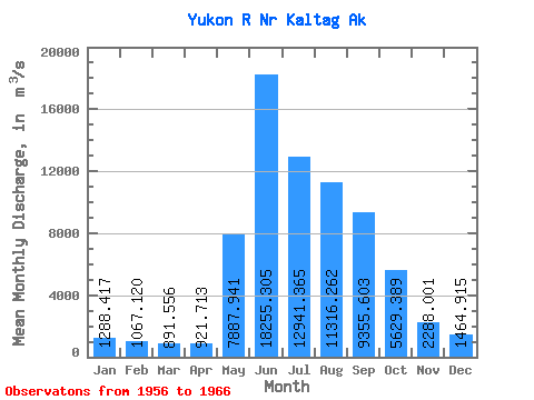
| Statistic | Jan | Feb | Mar | Apr | May | Jun | Jul | Aug | Sep | Oct | Nov | Dec | Annual |
|---|---|---|---|---|---|---|---|---|---|---|---|---|---|
| Mean | 1288.42 | 1067.12 | 891.56 | 921.71 | 7887.94 | 18255.31 | 12941.36 | 11316.26 | 9355.60 | 5629.39 | 2288.00 | 1464.91 | 6239.62 |
| Standard Deviation | 236.37 | 177.56 | 188.14 | 143.69 | 3278.30 | 4720.56 | 3169.31 | 2977.43 | 2519.55 | 1394.06 | 630.37 | 310.54 | 1090.90 |
| Min | 991.09 | 792.87 | 566.34 | 608.81 | 3502.79 | 12037.49 | 8401.61 | 7257.61 | 5179.15 | 3202.64 | 1642.38 | 1116.25 | 4444.26 |
| Max | 1727.33 | 1359.21 | 1132.67 | 1104.36 | 13345.73 | 26697.12 | 18199.24 | 16692.78 | 13509.97 | 7668.20 | 3681.19 | 2123.76 | 7879.16 |
| Coefficient of Variation | 0.18 | 0.17 | 0.21 | 0.16 | 0.42 | 0.26 | 0.24 | 0.26 | 0.27 | 0.25 | 0.28 | 0.21 | 0.17 |
 Return to R-Arctic Net Home Page