|
|
|||||||||||||||||
| Point ID: 7700 | Downloads | Plots | Site Data | Code: 15485500 |
|
|
|||||||||||||||||
| Download | |
|---|---|
| Site Descriptor Information | Site Time Series Data |
| Link to all available data | |
| View: | Time Series | All |
| Units: | mm |
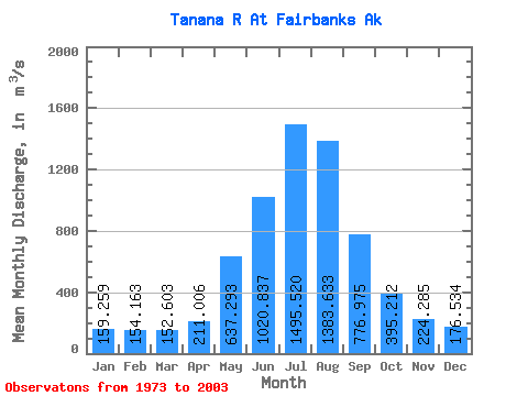
| Statistic | Jan | Feb | Mar | Apr | May | Jun | Jul | Aug | Sep | Oct | Nov | Dec | Annual |
|---|---|---|---|---|---|---|---|---|---|---|---|---|---|
| Mean | 159.26 | 154.16 | 152.60 | 211.01 | 637.29 | 1020.84 | 1495.52 | 1383.63 | 776.98 | 395.21 | 224.28 | 176.53 | 573.48 |
| Standard Deviation | 21.29 | 21.90 | 21.61 | 54.43 | 155.89 | 192.29 | 198.91 | 225.91 | 184.97 | 91.76 | 45.55 | 25.63 | 61.45 |
| Min | 113.72 | 90.81 | 87.78 | 119.78 | 419.27 | 711.32 | 1119.93 | 982.03 | 479.97 | 254.85 | 141.58 | 127.43 | 459.86 |
| Max | 202.04 | 189.72 | 191.45 | 359.62 | 1027.62 | 1454.07 | 1871.46 | 1984.55 | 1270.86 | 590.18 | 354.53 | 229.08 | 666.07 |
| Coefficient of Variation | 0.13 | 0.14 | 0.14 | 0.26 | 0.24 | 0.19 | 0.13 | 0.16 | 0.24 | 0.23 | 0.20 | 0.14 | 0.11 |
 Return to R-Arctic Net Home Page