|
|
|||||||||||||||||
| Point ID: 7686 | Downloads | Plots | Site Data | Code: 15564600 |
|
|
|||||||||||||||||
| Download | |
|---|---|
| Site Descriptor Information | Site Time Series Data |
| Link to all available data | |
| View: | Time Series | All |
| Units: | mm |
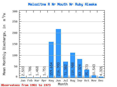
| Statistic | Jan | Feb | Mar | Apr | May | Jun | Jul | Aug | Sep | Oct | Nov | Dec | Annual |
|---|---|---|---|---|---|---|---|---|---|---|---|---|---|
| Mean | 2.50 | 1.79 | 1.47 | 1.75 | 159.65 | 216.99 | 71.38 | 110.99 | 83.32 | 35.57 | 10.54 | 4.33 | 57.43 |
| Standard Deviation | 2.01 | 1.46 | 1.09 | 1.01 | 104.21 | 94.82 | 35.36 | 91.59 | 59.77 | 28.13 | 5.84 | 2.53 | 21.08 |
| Min | 0.00 | 0.00 | 0.00 | 0.10 | 3.82 | 24.05 | 15.37 | 22.10 | 16.30 | 9.17 | 2.34 | 0.59 | 16.23 |
| Max | 6.79 | 4.81 | 3.40 | 3.68 | 344.41 | 317.81 | 140.65 | 300.55 | 207.01 | 116.37 | 23.21 | 9.62 | 85.74 |
| Coefficient of Variation | 0.80 | 0.82 | 0.74 | 0.58 | 0.65 | 0.44 | 0.49 | 0.82 | 0.72 | 0.79 | 0.55 | 0.58 | 0.37 |
 Return to R-Arctic Net Home Page