|
|
|||||||||||||||||
| Point ID: 7682 | Downloads | Plots | Site Data | Code: 15484000 |
|
|
|||||||||||||||||
| Download | |
|---|---|
| Site Descriptor Information | Site Time Series Data |
| Link to all available data | |
| View: | Time Series | All |
| Units: | mm |
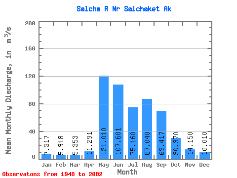
| Statistic | Jan | Feb | Mar | Apr | May | Jun | Jul | Aug | Sep | Oct | Nov | Dec | Annual |
|---|---|---|---|---|---|---|---|---|---|---|---|---|---|
| Mean | 7.32 | 5.92 | 5.35 | 11.29 | 121.01 | 107.60 | 75.16 | 87.04 | 69.42 | 30.37 | 14.15 | 10.01 | 45.00 |
| Standard Deviation | 2.64 | 2.51 | 2.25 | 7.95 | 54.30 | 56.06 | 37.34 | 57.82 | 37.41 | 10.92 | 4.14 | 3.33 | 14.10 |
| Min | 3.68 | 1.75 | 1.70 | 2.94 | 44.26 | 27.25 | 16.07 | 20.29 | 18.00 | 13.70 | 6.51 | 4.53 | 22.79 |
| Max | 13.33 | 12.71 | 10.67 | 38.86 | 245.25 | 244.51 | 207.44 | 377.81 | 175.06 | 55.72 | 29.09 | 20.66 | 84.37 |
| Coefficient of Variation | 0.36 | 0.42 | 0.42 | 0.70 | 0.45 | 0.52 | 0.50 | 0.66 | 0.54 | 0.36 | 0.29 | 0.33 | 0.31 |
 Return to R-Arctic Net Home Page