|
|
|||||||||||||||||
| Point ID: 768 | Downloads | Plots | Site Data | Other Close Sites | Code: 07GH001 |
|
|
|||||||||||||||||
| Download | |
|---|---|
| Site Descriptor Information | Site Time Series Data |
| Link to all available data | |
| View: | Time Series | All |
| Units: | mm |
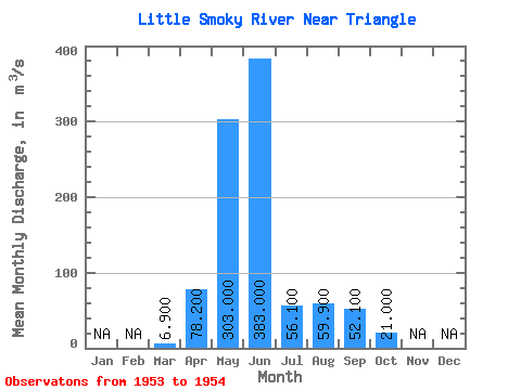
| Statistic | Jan | Feb | Mar | Apr | May | Jun | Jul | Aug | Sep | Oct | Nov | Dec | Annual |
|---|---|---|---|---|---|---|---|---|---|---|---|---|---|
| Mean | 6.90 | 78.20 | 303.00 | 383.00 | 56.10 | 59.90 | 52.10 | 21.00 | |||||
| Standard Deviation | 10.89 | ||||||||||||
| Min | 6.90 | 78.20 | 303.00 | 383.00 | 56.10 | 59.90 | 52.10 | 13.30 | |||||
| Max | 6.90 | 78.20 | 303.00 | 383.00 | 56.10 | 59.90 | 52.10 | 28.70 | |||||
| Coefficient of Variation | 0.52 |
| Other Close Sites | ||||||
|---|---|---|---|---|---|---|
| PointID | Latitude | Longitude | Drainage Area | Source | Name | |
| 769 | "LITTLE SMOKY RIVER NEAR GUY" | 55.45 | 1727298 | Hydat | ||
 Return to R-Arctic Net Home Page