|
|
|||||||||||||||||
| Point ID: 7674 | Downloads | Plots | Site Data | Code: 7201 |
|
|
|||||||||||||||||
| Download | |
|---|---|
| Site Descriptor Information | Site Time Series Data |
| Link to all available data | |
| View: | Time Series | All |
| Units: | mm |
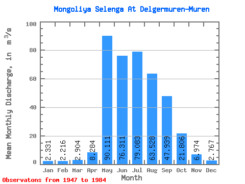
| Statistic | Jan | Feb | Mar | Apr | May | Jun | Jul | Aug | Sep | Oct | Nov | Dec | Annual |
|---|---|---|---|---|---|---|---|---|---|---|---|---|---|
| Mean | 2.33 | 2.22 | 2.90 | 8.28 | 90.11 | 76.31 | 79.08 | 63.53 | 47.94 | 21.81 | 6.97 | 2.77 | 35.01 |
| Standard Deviation | 1.30 | 0.85 | 1.36 | 8.72 | 46.44 | 30.64 | 58.34 | 51.50 | 39.35 | 10.79 | 3.12 | 0.98 | 15.21 |
| Min | 1.20 | 1.00 | 1.20 | 2.70 | 21.60 | 25.00 | 19.50 | 13.50 | 14.00 | 11.00 | 3.50 | 1.50 | 16.83 |
| Max | 6.46 | 3.57 | 5.05 | 32.50 | 210.00 | 118.00 | 258.00 | 234.00 | 183.00 | 55.00 | 17.50 | 4.78 | 78.62 |
| Coefficient of Variation | 0.56 | 0.39 | 0.47 | 1.05 | 0.52 | 0.40 | 0.74 | 0.81 | 0.82 | 0.49 | 0.45 | 0.35 | 0.43 |
 Return to R-Arctic Net Home Page