|
|
|||||||||||||||||
| Point ID: 767 | Downloads | Plots | Site Data | Code: 07GG003 |
|
|
|||||||||||||||||
| Download | |
|---|---|
| Site Descriptor Information | Site Time Series Data |
| Link to all available data | |
| View: | Time Series | All |
| Units: | mm |
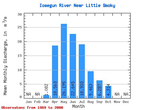
| Statistic | Jan | Feb | Mar | Apr | May | Jun | Jul | Aug | Sep | Oct | Nov | Dec | Annual |
|---|---|---|---|---|---|---|---|---|---|---|---|---|---|
| Mean | 1.08 | 18.56 | 26.20 | 22.64 | 18.93 | 9.46 | 6.29 | 4.31 | |||||
| Standard Deviation | 0.80 | 14.33 | 18.08 | 17.90 | 17.03 | 10.91 | 6.23 | 4.04 | |||||
| Min | 0.10 | 1.26 | 3.11 | 2.47 | 1.31 | 0.85 | 0.34 | 0.47 | |||||
| Max | 4.23 | 61.40 | 72.30 | 89.50 | 63.70 | 41.00 | 29.30 | 17.20 | |||||
| Coefficient of Variation | 0.74 | 0.77 | 0.69 | 0.79 | 0.90 | 1.15 | 0.99 | 0.94 |
 Return to R-Arctic Net Home Page