|
|
|||||||||||||||||
| Point ID: 7660 | Downloads | Plots | Site Data | Code: 71260 |
|
|
|||||||||||||||||
| Download | |
|---|---|
| Site Descriptor Information | Site Time Series Data |
| Link to all available data | |
| View: | Time Series | All |
| Units: | mm |
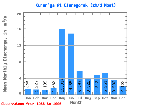
| Statistic | Jan | Feb | Mar | Apr | May | Jun | Jul | Aug | Sep | Oct | Nov | Dec | Annual |
|---|---|---|---|---|---|---|---|---|---|---|---|---|---|
| Mean | 1.43 | 1.23 | 1.20 | 1.66 | 15.91 | 14.85 | 5.80 | 3.92 | 4.81 | 5.25 | 3.58 | 2.10 | 5.16 |
| Standard Deviation | 0.61 | 0.66 | 0.75 | 1.17 | 7.64 | 6.97 | 3.58 | 2.52 | 2.84 | 2.37 | 1.53 | 0.69 | 1.26 |
| Min | 0.32 | 0.32 | 0.37 | 0.44 | 3.76 | 4.54 | 1.66 | 0.42 | 0.70 | 0.92 | 0.44 | 0.32 | 2.35 |
| Max | 2.96 | 3.30 | 4.96 | 6.34 | 32.50 | 31.40 | 17.00 | 10.80 | 17.30 | 11.60 | 9.77 | 3.62 | 9.01 |
| Coefficient of Variation | 0.43 | 0.54 | 0.62 | 0.70 | 0.48 | 0.47 | 0.62 | 0.64 | 0.59 | 0.45 | 0.43 | 0.33 | 0.24 |
 Return to R-Arctic Net Home Page