|
|
|||||||||||||||||
| Point ID: 7656 | Downloads | Plots | Site Data | Code: 71245 |
|
|
|||||||||||||||||
| Download | |
|---|---|
| Site Descriptor Information | Site Time Series Data |
| Link to all available data | |
| View: | Time Series | All |
| Units: | mm |
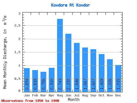
| Statistic | Jan | Feb | Mar | Apr | May | Jun | Jul | Aug | Sep | Oct | Nov | Dec | Annual |
|---|---|---|---|---|---|---|---|---|---|---|---|---|---|
| Mean | 0.89 | 0.82 | 0.76 | 0.91 | 2.74 | 2.19 | 1.85 | 1.67 | 1.61 | 1.43 | 1.23 | 1.01 | 1.43 |
| Standard Deviation | 0.22 | 0.23 | 0.24 | 0.39 | 0.76 | 0.75 | 0.77 | 0.41 | 0.33 | 0.30 | 0.26 | 0.24 | 0.28 |
| Min | 0.57 | 0.53 | 0.46 | 0.40 | 1.48 | 1.34 | 1.01 | 0.92 | 0.90 | 0.74 | 0.66 | 0.62 | 0.95 |
| Max | 1.33 | 1.26 | 1.17 | 1.89 | 4.02 | 3.83 | 3.65 | 2.57 | 2.24 | 1.88 | 1.66 | 1.45 | 1.88 |
| Coefficient of Variation | 0.24 | 0.28 | 0.31 | 0.43 | 0.28 | 0.34 | 0.42 | 0.24 | 0.21 | 0.21 | 0.22 | 0.23 | 0.20 |
 Return to R-Arctic Net Home Page