|
|
|||||||||||||||||
| Point ID: 7643 | Downloads | Plots | Site Data | Code: 71199 |
|
|
|||||||||||||||||
| Download | |
|---|---|
| Site Descriptor Information | Site Time Series Data |
| Link to all available data | |
| View: | Time Series | All |
| Units: | mm |
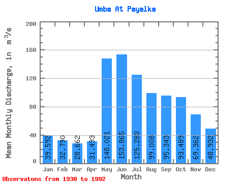
| Statistic | Jan | Feb | Mar | Apr | May | Jun | Jul | Aug | Sep | Oct | Nov | Dec | Annual |
|---|---|---|---|---|---|---|---|---|---|---|---|---|---|
| Mean | 39.59 | 32.79 | 28.66 | 31.49 | 148.02 | 153.87 | 125.28 | 99.01 | 95.34 | 93.49 | 69.36 | 48.93 | 79.85 |
| Standard Deviation | 9.48 | 7.73 | 6.72 | 10.19 | 55.05 | 44.80 | 33.26 | 29.10 | 32.49 | 34.49 | 24.32 | 12.12 | 16.10 |
| Min | 19.90 | 18.00 | 15.70 | 16.70 | 24.00 | 62.60 | 51.60 | 46.10 | 40.60 | 36.00 | 22.10 | 20.70 | 42.27 |
| Max | 62.00 | 52.40 | 46.40 | 67.60 | 254.00 | 252.00 | 198.00 | 164.00 | 181.00 | 248.00 | 128.00 | 78.30 | 123.61 |
| Coefficient of Variation | 0.24 | 0.24 | 0.23 | 0.32 | 0.37 | 0.29 | 0.27 | 0.29 | 0.34 | 0.37 | 0.35 | 0.25 | 0.20 |
 Return to R-Arctic Net Home Page