|
|
|||||||||||||||||
| Point ID: 760 | Downloads | Plots | Site Data | Code: 07GF004 |
|
|
|||||||||||||||||
| Download | |
|---|---|
| Site Descriptor Information | Site Time Series Data |
| Link to all available data | |
| View: | Time Series | All |
| Units: | mm |
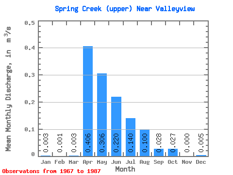
| Statistic | Jan | Feb | Mar | Apr | May | Jun | Jul | Aug | Sep | Oct | Nov | Dec | Annual |
|---|---|---|---|---|---|---|---|---|---|---|---|---|---|
| Mean | 0.00 | 0.00 | 0.00 | 0.41 | 0.31 | 0.22 | 0.14 | 0.10 | 0.03 | 0.03 | 0.00 | 0.01 | |
| Standard Deviation | 0.00 | 0.00 | 0.00 | 0.31 | 0.29 | 0.26 | 0.28 | 0.28 | 0.04 | 0.03 | 0.00 | ||
| Min | 0.00 | 0.00 | 0.00 | 0.02 | 0.03 | 0.01 | 0.00 | 0.00 | 0.00 | 0.00 | 0.00 | 0.00 | |
| Max | 0.00 | 0.00 | 0.01 | 1.23 | 0.91 | 0.93 | 1.19 | 1.25 | 0.15 | 0.11 | 0.00 | 0.01 | |
| Coefficient of Variation | 0.85 | 0.00 | 1.12 | 0.76 | 0.94 | 1.17 | 2.00 | 2.80 | 1.30 | 1.08 | 0.20 |
 Return to R-Arctic Net Home Page