|
|
|||||||||||||||||
| Point ID: 76 | Downloads | Plots | Site Data | Code: 05AC031 |
|
|
|||||||||||||||||
| Download | |
|---|---|
| Site Descriptor Information | Site Time Series Data |
| Link to all available data | |
| View: | Time Series | All |
| Units: | mm |
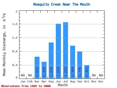
| Statistic | Jan | Feb | Mar | Apr | May | Jun | Jul | Aug | Sep | Oct | Nov | Dec | Annual |
|---|---|---|---|---|---|---|---|---|---|---|---|---|---|
| Mean | 0.64 | 0.49 | 1.06 | 1.61 | 1.65 | 0.96 | 0.80 | 0.40 | |||||
| Standard Deviation | 1.12 | 0.46 | 0.69 | 1.21 | 1.38 | 0.61 | 0.58 | 0.34 | |||||
| Min | 0.03 | 0.04 | 0.36 | 0.68 | 0.66 | 0.35 | 0.17 | 0.11 | |||||
| Max | 4.35 | 1.77 | 2.69 | 6.08 | 6.84 | 2.62 | 2.93 | 1.71 | |||||
| Coefficient of Variation | 1.75 | 0.94 | 0.65 | 0.75 | 0.83 | 0.63 | 0.73 | 0.85 |
 Return to R-Arctic Net Home Page