|
|
|||||||||||||||||
| Point ID: 7575 | Downloads | Plots | Site Data | Code: 71035 |
|
|
|||||||||||||||||
| Download | |
|---|---|
| Site Descriptor Information | Site Time Series Data |
| Link to all available data | |
| View: | Time Series | All |
| Units: | mm |
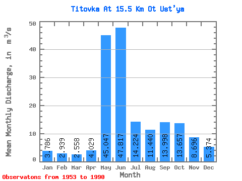
| Statistic | Jan | Feb | Mar | Apr | May | Jun | Jul | Aug | Sep | Oct | Nov | Dec | Annual |
|---|---|---|---|---|---|---|---|---|---|---|---|---|---|
| Mean | 3.79 | 2.94 | 2.56 | 4.03 | 45.05 | 47.82 | 14.22 | 11.44 | 14.00 | 13.66 | 8.70 | 5.37 | 14.43 |
| Standard Deviation | 0.81 | 0.54 | 0.51 | 4.32 | 23.37 | 24.11 | 7.76 | 6.52 | 8.40 | 5.10 | 3.57 | 1.40 | 3.06 |
| Min | 2.10 | 1.61 | 1.39 | 1.09 | 6.24 | 13.00 | 3.46 | 1.98 | 5.92 | 5.00 | 3.28 | 2.75 | 8.70 |
| Max | 5.90 | 4.00 | 3.61 | 21.50 | 106.00 | 105.00 | 35.10 | 32.00 | 51.00 | 28.10 | 24.20 | 8.53 | 20.18 |
| Coefficient of Variation | 0.21 | 0.18 | 0.20 | 1.07 | 0.52 | 0.50 | 0.55 | 0.57 | 0.60 | 0.37 | 0.41 | 0.26 | 0.21 |
 Return to R-Arctic Net Home Page