|
|
|||||||||||||||||
| Point ID: 7568 | Downloads | Plots | Site Data | Code: 70850 |
|
|
|||||||||||||||||
| Download | |
|---|---|
| Site Descriptor Information | Site Time Series Data |
| Link to all available data | |
| View: | Time Series | All |
| Units: | mm |
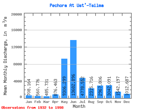
| Statistic | Jan | Feb | Mar | Apr | May | Jun | Jul | Aug | Sep | Oct | Nov | Dec | Annual |
|---|---|---|---|---|---|---|---|---|---|---|---|---|---|
| Mean | 708.16 | 560.78 | 485.73 | 876.46 | 9306.30 | 13682.90 | 4778.55 | 2315.72 | 2967.81 | 3042.09 | 1542.20 | 1012.69 | 3439.60 |
| Standard Deviation | 139.48 | 125.88 | 117.03 | 1003.80 | 4332.91 | 4690.15 | 1967.37 | 903.60 | 1237.96 | 1173.44 | 645.97 | 230.10 | 423.54 |
| Min | 426.00 | 331.00 | 250.00 | 251.00 | 1790.00 | 5700.00 | 1950.00 | 1150.00 | 981.00 | 779.00 | 457.00 | 305.00 | 2575.83 |
| Max | 1000.00 | 832.00 | 712.00 | 6460.00 | 18400.00 | 24300.00 | 11800.00 | 5170.00 | 5750.00 | 5990.00 | 4000.00 | 1650.00 | 4345.83 |
| Coefficient of Variation | 0.20 | 0.22 | 0.24 | 1.15 | 0.47 | 0.34 | 0.41 | 0.39 | 0.42 | 0.39 | 0.42 | 0.23 | 0.12 |
 Return to R-Arctic Net Home Page