|
|
|||||||||||||||||
| Point ID: 7566 | Downloads | Plots | Site Data | Code: 70842 |
|
|
|||||||||||||||||
| Download | |
|---|---|
| Site Descriptor Information | Site Time Series Data |
| Link to all available data | |
| View: | Time Series | All |
| Units: | mm |
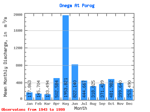
| Statistic | Jan | Feb | Mar | Apr | May | Jun | Jul | Aug | Sep | Oct | Nov | Dec | Annual |
|---|---|---|---|---|---|---|---|---|---|---|---|---|---|
| Mean | 177.86 | 145.70 | 133.49 | 502.58 | 1953.82 | 822.14 | 444.67 | 318.82 | 371.44 | 481.98 | 399.64 | 253.49 | 492.10 |
| Standard Deviation | 50.40 | 34.21 | 32.08 | 423.85 | 525.21 | 273.15 | 154.59 | 139.63 | 233.82 | 256.53 | 213.10 | 123.05 | 98.46 |
| Min | 103.00 | 87.40 | 85.70 | 97.80 | 791.00 | 364.00 | 199.00 | 161.00 | 140.00 | 151.00 | 121.00 | 115.00 | 309.08 |
| Max | 293.00 | 219.00 | 252.00 | 1662.00 | 3100.00 | 1650.00 | 801.00 | 889.00 | 1190.00 | 1130.00 | 885.00 | 677.00 | 737.83 |
| Coefficient of Variation | 0.28 | 0.23 | 0.24 | 0.84 | 0.27 | 0.33 | 0.35 | 0.44 | 0.63 | 0.53 | 0.53 | 0.48 | 0.20 |
 Return to R-Arctic Net Home Page