|
|
|||||||||||||||||
| Point ID: 756 | Downloads | Plots | Site Data | Code: 07GE007 |
|
|
|||||||||||||||||
| Download | |
|---|---|
| Site Descriptor Information | Site Time Series Data |
| Link to all available data | |
| View: | Time Series | All |
| Units: | mm |
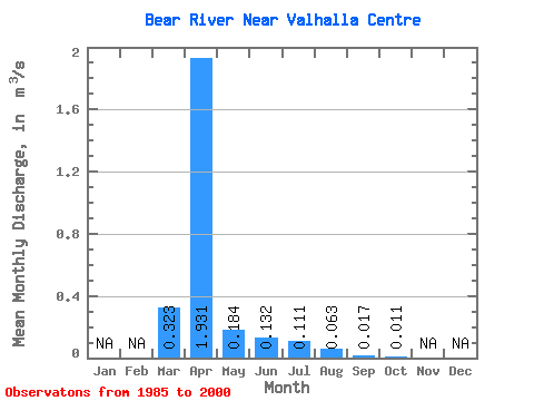
| Statistic | Jan | Feb | Mar | Apr | May | Jun | Jul | Aug | Sep | Oct | Nov | Dec | Annual |
|---|---|---|---|---|---|---|---|---|---|---|---|---|---|
| Mean | 0.32 | 1.93 | 0.18 | 0.13 | 0.11 | 0.06 | 0.02 | 0.01 | |||||
| Standard Deviation | 0.51 | 2.14 | 0.34 | 0.31 | 0.30 | 0.24 | 0.04 | 0.03 | |||||
| Min | 0.00 | 0.12 | 0.00 | 0.00 | 0.00 | 0.00 | 0.00 | 0.00 | |||||
| Max | 1.84 | 8.06 | 1.32 | 1.20 | 1.20 | 0.95 | 0.12 | 0.12 | |||||
| Coefficient of Variation | 1.57 | 1.11 | 1.84 | 2.35 | 2.72 | 3.74 | 2.02 | 2.87 |
 Return to R-Arctic Net Home Page