|
|
|||||||||||||||||
| Point ID: 753 | Downloads | Plots | Site Data | Code: 07GE003 |
|
|
|||||||||||||||||
| Download | |
|---|---|
| Site Descriptor Information | Site Time Series Data |
| Link to all available data | |
| View: | Time Series | All |
| Units: | mm |
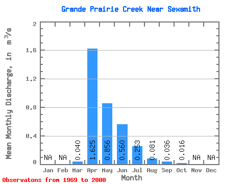
| Statistic | Jan | Feb | Mar | Apr | May | Jun | Jul | Aug | Sep | Oct | Nov | Dec | Annual |
|---|---|---|---|---|---|---|---|---|---|---|---|---|---|
| Mean | 0.04 | 1.62 | 0.86 | 0.56 | 0.25 | 0.08 | 0.04 | 0.02 | |||||
| Standard Deviation | 0.12 | 1.52 | 0.90 | 0.99 | 0.55 | 0.28 | 0.11 | 0.04 | |||||
| Min | 0.00 | 0.03 | 0.00 | 0.01 | 0.00 | 0.00 | 0.00 | 0.00 | |||||
| Max | 0.61 | 5.45 | 3.07 | 4.55 | 2.77 | 1.43 | 0.49 | 0.18 | |||||
| Coefficient of Variation | 2.90 | 0.93 | 1.05 | 1.77 | 2.19 | 3.47 | 2.98 | 2.44 |
 Return to R-Arctic Net Home Page