|
|
|||||||||||||||||
| Point ID: 7518 | Downloads | Plots | Site Data | Code: 70530 |
|
|
|||||||||||||||||
| Download | |
|---|---|
| Site Descriptor Information | Site Time Series Data |
| Link to all available data | |
| View: | Time Series | All |
| Units: | mm |
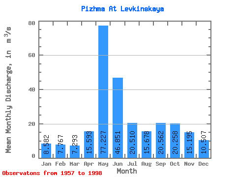
| Statistic | Jan | Feb | Mar | Apr | May | Jun | Jul | Aug | Sep | Oct | Nov | Dec | Annual |
|---|---|---|---|---|---|---|---|---|---|---|---|---|---|
| Mean | 8.58 | 7.77 | 7.29 | 15.59 | 77.23 | 46.85 | 20.51 | 15.68 | 20.56 | 20.26 | 15.20 | 10.51 | 22.08 |
| Standard Deviation | 1.28 | 1.11 | 1.36 | 15.82 | 24.28 | 24.70 | 7.62 | 6.10 | 8.47 | 6.88 | 5.96 | 2.56 | 3.70 |
| Min | 5.98 | 5.78 | 1.35 | 5.77 | 34.50 | 14.30 | 10.30 | 9.06 | 9.74 | 9.00 | 6.82 | 7.04 | 16.32 |
| Max | 11.70 | 11.20 | 9.89 | 73.10 | 148.00 | 146.00 | 44.40 | 36.90 | 38.70 | 34.70 | 34.40 | 22.50 | 31.41 |
| Coefficient of Variation | 0.15 | 0.14 | 0.19 | 1.01 | 0.31 | 0.53 | 0.37 | 0.39 | 0.41 | 0.34 | 0.39 | 0.24 | 0.17 |
 Return to R-Arctic Net Home Page