|
|
|||||||||||||||||
| Point ID: 7509 | Downloads | Plots | Site Data | Code: 70506 |
|
|
|||||||||||||||||
| Download | |
|---|---|
| Site Descriptor Information | Site Time Series Data |
| Link to all available data | |
| View: | Time Series | All |
| Units: | mm |
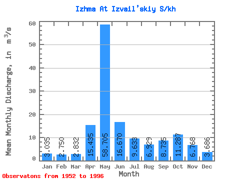
| Statistic | Jan | Feb | Mar | Apr | May | Jun | Jul | Aug | Sep | Oct | Nov | Dec | Annual |
|---|---|---|---|---|---|---|---|---|---|---|---|---|---|
| Mean | 3.04 | 2.75 | 2.83 | 15.44 | 58.70 | 16.67 | 9.63 | 6.93 | 8.73 | 11.29 | 6.77 | 3.69 | 12.18 |
| Standard Deviation | 0.51 | 0.46 | 0.63 | 16.90 | 20.10 | 8.61 | 6.67 | 3.98 | 4.68 | 5.71 | 3.23 | 0.81 | 2.01 |
| Min | 1.77 | 1.69 | 1.68 | 2.10 | 18.10 | 5.12 | 0.68 | 3.35 | 3.60 | 4.63 | 2.81 | 2.54 | 8.16 |
| Max | 4.13 | 3.76 | 4.45 | 66.30 | 93.60 | 40.00 | 31.50 | 21.00 | 24.50 | 29.80 | 18.00 | 5.60 | 16.40 |
| Coefficient of Variation | 0.17 | 0.17 | 0.22 | 1.09 | 0.34 | 0.52 | 0.69 | 0.57 | 0.54 | 0.51 | 0.48 | 0.22 | 0.17 |
 Return to R-Arctic Net Home Page