|
|
|||||||||||||||||
| Point ID: 7459 | Downloads | Plots | Site Data | Code: 70362 |
|
|
|||||||||||||||||
| Download | |
|---|---|
| Site Descriptor Information | Site Time Series Data |
| Link to all available data | |
| View: | Time Series | All |
| Units: | mm |
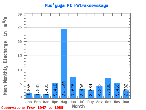
| Statistic | Jan | Feb | Mar | Apr | May | Jun | Jul | Aug | Sep | Oct | Nov | Dec | Annual |
|---|---|---|---|---|---|---|---|---|---|---|---|---|---|
| Mean | 1.86 | 1.58 | 1.44 | 5.42 | 24.47 | 7.63 | 3.41 | 2.88 | 4.34 | 7.14 | 5.47 | 2.78 | 5.69 |
| Standard Deviation | 0.61 | 0.41 | 0.30 | 5.96 | 6.68 | 5.23 | 1.73 | 1.92 | 2.55 | 3.59 | 2.64 | 1.27 | 1.10 |
| Min | 1.22 | 0.85 | 0.73 | 1.18 | 9.42 | 2.27 | 1.50 | 1.36 | 1.74 | 2.03 | 1.66 | 1.26 | 3.58 |
| Max | 3.91 | 2.70 | 2.04 | 23.80 | 40.70 | 21.00 | 9.35 | 8.65 | 11.90 | 15.60 | 10.70 | 7.01 | 8.04 |
| Coefficient of Variation | 0.33 | 0.26 | 0.21 | 1.10 | 0.27 | 0.69 | 0.51 | 0.67 | 0.59 | 0.50 | 0.48 | 0.46 | 0.19 |
 Return to R-Arctic Net Home Page