|
|
|||||||||||||||||
| Point ID: 7441 | Downloads | Plots | Site Data | Code: 70329 |
|
|
|||||||||||||||||
| Download | |
|---|---|
| Site Descriptor Information | Site Time Series Data |
| Link to all available data | |
| View: | Time Series | All |
| Units: | mm |
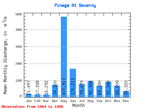
| Statistic | Jan | Feb | Mar | Apr | May | Jun | Jul | Aug | Sep | Oct | Nov | Dec | Annual |
|---|---|---|---|---|---|---|---|---|---|---|---|---|---|
| Mean | 21.50 | 17.34 | 16.29 | 74.30 | 477.92 | 170.21 | 79.48 | 95.91 | 69.18 | 92.35 | 68.81 | 36.32 | 101.03 |
| Standard Deviation | 6.06 | 4.53 | 3.77 | 96.20 | 129.31 | 67.22 | 47.16 | 200.78 | 34.81 | 42.24 | 33.87 | 16.76 | 22.40 |
| Min | 9.52 | 8.51 | 9.90 | 15.80 | 232.00 | 71.50 | 23.10 | 23.40 | 21.40 | 31.70 | 24.50 | 19.10 | 66.13 |
| Max | 36.90 | 25.40 | 28.30 | 435.00 | 726.00 | 330.00 | 208.00 | 1010.00 | 142.00 | 201.00 | 139.00 | 83.30 | 188.80 |
| Coefficient of Variation | 0.28 | 0.26 | 0.23 | 1.29 | 0.27 | 0.40 | 0.59 | 2.09 | 0.50 | 0.46 | 0.49 | 0.46 | 0.22 |
 Return to R-Arctic Net Home Page