|
|
|||||||||||||||||
| Point ID: 7414 | Downloads | Plots | Site Data | Code: 70255 |
|
|
|||||||||||||||||
| Download | |
|---|---|
| Site Descriptor Information | Site Time Series Data |
| Link to all available data | |
| View: | Time Series | All |
| Units: | mm |
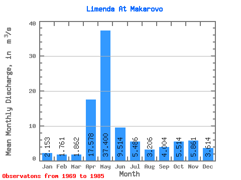
| Statistic | Jan | Feb | Mar | Apr | May | Jun | Jul | Aug | Sep | Oct | Nov | Dec | Annual |
|---|---|---|---|---|---|---|---|---|---|---|---|---|---|
| Mean | 2.15 | 1.76 | 1.86 | 17.58 | 37.40 | 9.51 | 5.49 | 3.21 | 4.00 | 5.51 | 5.86 | 3.61 | 7.97 |
| Standard Deviation | 0.72 | 0.48 | 0.51 | 12.68 | 18.06 | 5.73 | 3.78 | 1.83 | 2.21 | 2.44 | 3.94 | 2.44 | 1.46 |
| Min | 1.30 | 1.17 | 1.27 | 2.73 | 10.80 | 2.91 | 1.80 | 1.79 | 2.16 | 2.65 | 2.08 | 1.80 | 4.99 |
| Max | 3.81 | 2.88 | 3.10 | 50.40 | 65.60 | 25.50 | 14.10 | 9.18 | 11.00 | 9.98 | 15.90 | 9.90 | 10.16 |
| Coefficient of Variation | 0.33 | 0.28 | 0.27 | 0.72 | 0.48 | 0.60 | 0.69 | 0.57 | 0.55 | 0.44 | 0.67 | 0.68 | 0.18 |
 Return to R-Arctic Net Home Page