|
|
|||||||||||||||||
| Point ID: 7412 | Downloads | Plots | Site Data | Code: 70250 |
|
|
|||||||||||||||||
| Download | |
|---|---|
| Site Descriptor Information | Site Time Series Data |
| Link to all available data | |
| View: | Time Series | All |
| Units: | mm |
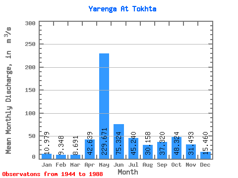
| Statistic | Jan | Feb | Mar | Apr | May | Jun | Jul | Aug | Sep | Oct | Nov | Dec | Annual |
|---|---|---|---|---|---|---|---|---|---|---|---|---|---|
| Mean | 10.98 | 9.35 | 8.69 | 42.64 | 229.67 | 75.32 | 45.24 | 30.16 | 37.32 | 48.32 | 31.49 | 15.46 | 48.71 |
| Standard Deviation | 2.20 | 1.97 | 1.69 | 49.03 | 79.03 | 31.96 | 31.68 | 22.94 | 24.13 | 24.46 | 15.32 | 5.47 | 9.09 |
| Min | 6.53 | 3.70 | 2.83 | 4.82 | 78.20 | 22.50 | 13.90 | 11.70 | 11.50 | 16.20 | 10.50 | 10.30 | 33.21 |
| Max | 16.50 | 13.40 | 12.50 | 244.00 | 386.00 | 196.00 | 142.00 | 131.00 | 151.00 | 132.00 | 69.40 | 40.20 | 72.63 |
| Coefficient of Variation | 0.20 | 0.21 | 0.19 | 1.15 | 0.34 | 0.42 | 0.70 | 0.76 | 0.65 | 0.51 | 0.49 | 0.35 | 0.19 |
 Return to R-Arctic Net Home Page