|
|
|||||||||||||||||
| Point ID: 7400 | Downloads | Plots | Site Data | Code: 70221 |
|
|
|||||||||||||||||
| Download | |
|---|---|
| Site Descriptor Information | Site Time Series Data |
| Link to all available data | |
| View: | Time Series | All |
| Units: | mm |
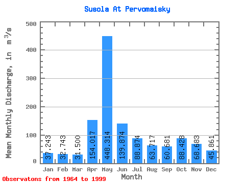
| Statistic | Jan | Feb | Mar | Apr | May | Jun | Jul | Aug | Sep | Oct | Nov | Dec | Annual |
|---|---|---|---|---|---|---|---|---|---|---|---|---|---|
| Mean | 37.24 | 32.74 | 31.50 | 154.02 | 448.31 | 139.87 | 88.87 | 63.72 | 60.68 | 88.43 | 68.68 | 45.86 | 105.04 |
| Standard Deviation | 8.76 | 7.09 | 6.06 | 117.84 | 180.61 | 69.30 | 45.02 | 34.98 | 22.62 | 34.71 | 28.90 | 12.88 | 21.83 |
| Min | 14.40 | 12.70 | 12.80 | 37.60 | 107.00 | 47.80 | 22.60 | 14.50 | 17.70 | 39.90 | 23.10 | 13.10 | 45.72 |
| Max | 62.40 | 54.20 | 43.60 | 465.00 | 864.00 | 288.00 | 218.00 | 200.00 | 122.00 | 166.00 | 172.00 | 78.40 | 146.58 |
| Coefficient of Variation | 0.23 | 0.22 | 0.19 | 0.77 | 0.40 | 0.49 | 0.51 | 0.55 | 0.37 | 0.39 | 0.42 | 0.28 | 0.21 |
 Return to R-Arctic Net Home Page