|
|
|||||||||||||||||
| Point ID: 74 | Downloads | Plots | Site Data | Code: 05AC029 |
|
|
|||||||||||||||||
| Download | |
|---|---|
| Site Descriptor Information | Site Time Series Data |
| Link to all available data | |
| View: | Time Series | All |
| Units: | mm |
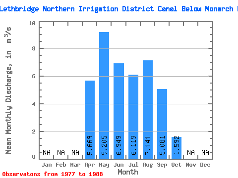
| Statistic | Jan | Feb | Mar | Apr | May | Jun | Jul | Aug | Sep | Oct | Nov | Dec | Annual |
|---|---|---|---|---|---|---|---|---|---|---|---|---|---|
| Mean | 5.67 | 9.21 | 6.95 | 6.12 | 7.14 | 5.08 | 1.59 | ||||||
| Standard Deviation | 2.44 | 4.51 | 3.49 | 1.70 | 1.81 | 2.91 | 1.34 | ||||||
| Min | 1.18 | 3.47 | 2.53 | 3.37 | 3.29 | 0.83 | 0.00 | ||||||
| Max | 8.58 | 18.70 | 14.20 | 8.31 | 10.10 | 9.12 | 3.62 | ||||||
| Coefficient of Variation | 0.43 | 0.49 | 0.50 | 0.28 | 0.25 | 0.57 | 0.84 |
 Return to R-Arctic Net Home Page