|
|
|||||||||||||||||
| Point ID: 7399 | Downloads | Plots | Site Data | Code: 70217 |
|
|
|||||||||||||||||
| Download | |
|---|---|
| Site Descriptor Information | Site Time Series Data |
| Link to all available data | |
| View: | Time Series | All |
| Units: | mm |
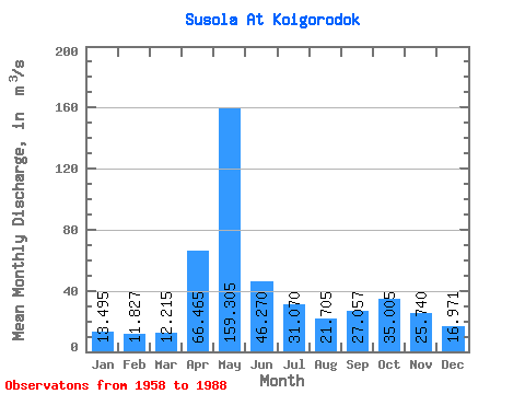
| Statistic | Jan | Feb | Mar | Apr | May | Jun | Jul | Aug | Sep | Oct | Nov | Dec | Annual |
|---|---|---|---|---|---|---|---|---|---|---|---|---|---|
| Mean | 13.49 | 11.83 | 12.21 | 66.47 | 159.31 | 46.27 | 31.07 | 21.70 | 27.06 | 35.01 | 25.74 | 16.97 | 38.96 |
| Standard Deviation | 3.33 | 1.83 | 2.09 | 43.84 | 87.11 | 24.57 | 12.68 | 10.08 | 15.70 | 16.95 | 11.08 | 5.45 | 7.43 |
| Min | 8.80 | 7.97 | 8.72 | 17.20 | 29.20 | 20.10 | 15.00 | 10.90 | 10.40 | 12.50 | 9.94 | 10.70 | 25.05 |
| Max | 24.10 | 15.30 | 17.60 | 155.00 | 357.00 | 129.00 | 55.00 | 41.70 | 79.70 | 74.40 | 54.70 | 34.30 | 51.03 |
| Coefficient of Variation | 0.25 | 0.15 | 0.17 | 0.66 | 0.55 | 0.53 | 0.41 | 0.46 | 0.58 | 0.48 | 0.43 | 0.32 | 0.19 |
 Return to R-Arctic Net Home Page