|
|
|||||||||||||||||
| Point ID: 7379 | Downloads | Plots | Site Data | Code: 70165 |
|
|
|||||||||||||||||
| Download | |
|---|---|
| Site Descriptor Information | Site Time Series Data |
| Link to all available data | |
| View: | Time Series | All |
| Units: | mm |
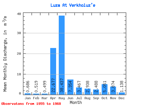
| Statistic | Jan | Feb | Mar | Apr | May | Jun | Jul | Aug | Sep | Oct | Nov | Dec | Annual |
|---|---|---|---|---|---|---|---|---|---|---|---|---|---|
| Mean | 0.69 | 0.52 | 0.50 | 22.68 | 38.44 | 7.35 | 3.47 | 2.94 | 2.49 | 5.05 | 3.87 | 1.14 | 7.39 |
| Standard Deviation | 0.34 | 0.23 | 0.18 | 18.08 | 19.63 | 8.93 | 2.73 | 4.51 | 3.58 | 4.86 | 3.40 | 0.82 | 2.71 |
| Min | 0.09 | 0.11 | 0.11 | 1.31 | 9.35 | 1.76 | 0.64 | 0.33 | 0.49 | 0.61 | 0.70 | 0.25 | 3.59 |
| Max | 1.25 | 1.11 | 0.91 | 71.80 | 64.30 | 35.30 | 9.35 | 16.80 | 14.00 | 16.60 | 11.70 | 2.85 | 13.92 |
| Coefficient of Variation | 0.50 | 0.44 | 0.36 | 0.80 | 0.51 | 1.21 | 0.79 | 1.54 | 1.44 | 0.96 | 0.88 | 0.72 | 0.37 |
 Return to R-Arctic Net Home Page