|
|
|||||||||||||||||
| Point ID: 7372 | Downloads | Plots | Site Data | Code: 70155 |
|
|
|||||||||||||||||
| Download | |
|---|---|
| Site Descriptor Information | Site Time Series Data |
| Link to all available data | |
| View: | Time Series | All |
| Units: | mm |
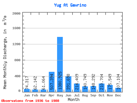
| Statistic | Jan | Feb | Mar | Apr | May | Jun | Jul | Aug | Sep | Oct | Nov | Dec | Annual |
|---|---|---|---|---|---|---|---|---|---|---|---|---|---|
| Mean | 74.32 | 62.14 | 61.06 | 507.39 | 1380.92 | 391.70 | 214.41 | 140.75 | 148.29 | 210.70 | 175.55 | 107.10 | 289.53 |
| Standard Deviation | 22.17 | 13.86 | 10.58 | 304.61 | 582.13 | 225.18 | 126.18 | 91.01 | 143.36 | 157.80 | 112.26 | 47.99 | 68.44 |
| Min | 30.00 | 36.00 | 42.90 | 76.80 | 342.00 | 103.00 | 66.90 | 58.50 | 56.10 | 72.10 | 65.30 | 43.90 | 141.00 |
| Max | 160.00 | 110.00 | 94.20 | 1310.00 | 2720.00 | 1010.00 | 548.00 | 448.00 | 996.00 | 1020.00 | 654.00 | 309.00 | 530.02 |
| Coefficient of Variation | 0.30 | 0.22 | 0.17 | 0.60 | 0.42 | 0.57 | 0.59 | 0.65 | 0.97 | 0.75 | 0.64 | 0.45 | 0.24 |
 Return to R-Arctic Net Home Page