|
|
|||||||||||||||||
| Point ID: 7361 | Downloads | Plots | Site Data | Code: 70130 |
|
|
|||||||||||||||||
| Download | |
|---|---|
| Site Descriptor Information | Site Time Series Data |
| Link to all available data | |
| View: | Time Series | All |
| Units: | mm |
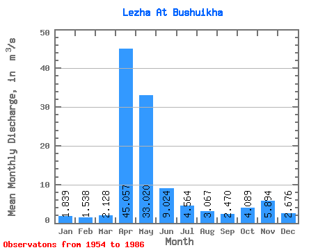
| Statistic | Jan | Feb | Mar | Apr | May | Jun | Jul | Aug | Sep | Oct | Nov | Dec | Annual |
|---|---|---|---|---|---|---|---|---|---|---|---|---|---|
| Mean | 1.84 | 1.54 | 2.13 | 45.06 | 33.02 | 9.02 | 4.56 | 3.07 | 2.47 | 4.09 | 5.89 | 2.68 | 9.73 |
| Standard Deviation | 0.68 | 0.47 | 1.81 | 20.77 | 24.49 | 9.90 | 4.42 | 2.09 | 1.88 | 5.13 | 6.31 | 1.48 | 3.04 |
| Min | 1.01 | 0.49 | 0.57 | 17.60 | 2.32 | 1.02 | 1.00 | 1.12 | 1.12 | 1.23 | 1.19 | 1.20 | 4.68 |
| Max | 3.90 | 2.59 | 9.30 | 104.00 | 106.00 | 35.70 | 19.30 | 9.60 | 8.62 | 28.10 | 26.80 | 5.77 | 16.01 |
| Coefficient of Variation | 0.37 | 0.31 | 0.85 | 0.46 | 0.74 | 1.10 | 0.97 | 0.68 | 0.76 | 1.25 | 1.07 | 0.55 | 0.31 |
 Return to R-Arctic Net Home Page