|
|
|||||||||||||||||
| Point ID: 7352 | Downloads | Plots | Site Data | Code: 70102 |
|
|
|||||||||||||||||
| Download | |
|---|---|
| Site Descriptor Information | Site Time Series Data |
| Link to all available data | |
| View: | Time Series | All |
| Units: | mm |
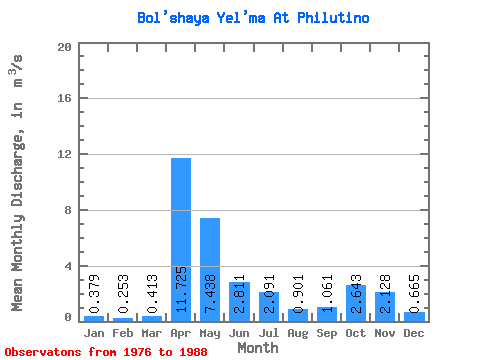
| Statistic | Jan | Feb | Mar | Apr | May | Jun | Jul | Aug | Sep | Oct | Nov | Dec | Annual |
|---|---|---|---|---|---|---|---|---|---|---|---|---|---|
| Mean | 0.38 | 0.25 | 0.41 | 11.72 | 7.44 | 2.81 | 2.09 | 0.90 | 1.06 | 2.64 | 2.13 | 0.67 | 2.71 |
| Standard Deviation | 0.44 | 0.26 | 0.51 | 4.52 | 4.78 | 3.75 | 1.82 | 1.16 | 1.31 | 2.74 | 1.60 | 0.48 | 0.48 |
| Min | 0.06 | 0.04 | 0.05 | 5.51 | 1.18 | 0.19 | 0.08 | 0.06 | 0.10 | 0.14 | 0.10 | 0.10 | 1.82 |
| Max | 1.63 | 0.97 | 2.03 | 18.00 | 16.60 | 11.30 | 6.67 | 3.50 | 3.61 | 8.81 | 4.50 | 1.53 | 3.36 |
| Coefficient of Variation | 1.17 | 1.04 | 1.23 | 0.39 | 0.64 | 1.33 | 0.87 | 1.29 | 1.24 | 1.03 | 0.75 | 0.72 | 0.18 |
 Return to R-Arctic Net Home Page